-
Model:
ADMT-7B
-
Features:
The ADMT-7B replaces bulky traditional systems with a compact, lightweight design. With intelligent analysis software, it offers easy operation and efficient field performance.
High Accuracy using the most advanced circuit design, single chip microcomputer control, automatic noise reduction,digital filtering to highly improve survey accuracy and stability.
Easy to operate humanized man-machine interface, built-in all kinds of formulas to read VP, IP, RO, M, TH... parameters.
More Parameters could measure VP, IP, SP, RO, M, TH....
Complete Equipment four poles to detect depth, intermediate gradient, combined profile, five poles, three poles etc....about 30 kinds.
ADMT-7B Multi-Function Electrical Resistivity & IP Survey System
R&D Since 1973

Free upgrading at the original price after purchasing within six months
The ADMT-7B is designed to replace traditional bulky and heavy resistivity equipment with a compact and lightweight solution. Equipped with intelligent analysis software, it delivers easy operation and efficient field performance.


Light &
Portable

Accurate
& Stable

Fully
Equipped

Simple
Operation
MEET YOUR VARIOUS NEEDS

Iron Mineral Exploration

Water Source Survey

Environmental Census

Engineering Investigation
Engineering Survey: Widely used in geotechnical investigations for railways, bridges, and urban projects, as well as archaeological surveys and underground pipeline detection, supporting both detailed and preliminary exploration.
Geological Survey: Applied in detecting mined-out areas, groundwater hazards, dam risks, fault zones, collapse columns, and slope instability, for both detailed and regional hydrogeological investigations.
FIVE ADVANTAGES
TO HELP YOU EXPLORE WORRY-FREE
Highly Intelligent, Easy to Operate
 The system is equipped with a self-developed APP based on the Android operating system, providing high levels of intelligence and smooth interaction. It is compatible with most Android and HarmonyOS devices, including smartphones, tablets, and the company’s professional intelligent control hosts. From parameter settings and data collection to mapping and imaging, the entire process is visually guided, greatly reducing reliance on operator experience and providing efficient and convenient support.
Precise and Reliable, Immune to Interference
 The system adopts the latest circuit design, combining automatic noise reduction with analog and digital filtering. It effectively extracts weak, real signals even in high-interference environments, ensuring that the data collected is stable, pure, and repeatable. This provides a solid foundation of trust for your decision-making.
Multiple Parameters, Strong Interpretability
 The system simultaneously acquires multiple parameters such as VP, IP, SP, RO, M, TH, Z, and D. It also supports polarization decay curve results. The cross-validation of multiple parameters significantly reduces ambiguity in geological interpretation, making the judgment of subsurface anomalies more accurate.
Lightweight and Versatile Device Modes
 The system features a lightweight design for easy field transport. It includes ten different mode types, such as four-electrode depth measurement, intermediate gradient, and joint profile. The system is adaptable to various tasks, from profile scanning to 3D area exploration, allowing a single device to handle a wide range of scenarios.
Flexible Expansion, Long-Term Investment
 The system can be paired with a line-borrowing remote control system, easily upgrading to low-density, deep-exploration configurations. The device’s capabilities can grow alongside your business, effectively protecting the initial investment while meeting future, more demanding exploration challenges.
BEAUTIFUL IN SHAPE

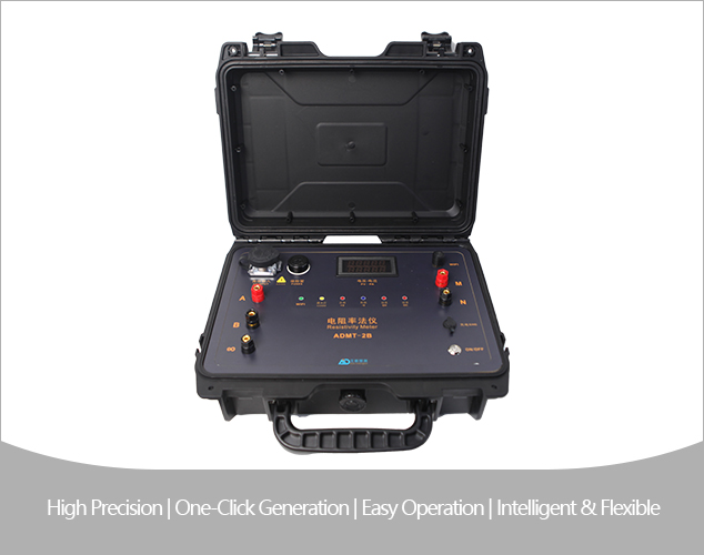
① Fuse ② HV Input ③ V/A Display ④ A/B Terminals ⑤ Remote Terminal ⑥ WiFi Indicator ⑦ Status Indicators ⑧ WiFi Antenna ⑨ M/N Terminals ⑩ Charging Port ⑪ Data Port ⑫ Power Switch
MAIN MODELS
AND TECHNICAL PARAMETERS
| Model | ADMT-7B |
|---|---|
| Voltage Resolution | 0.5 μV |
| SP Compensation Range | ±3000 mV |
| Voltage Measurement Range | 14000 mV |
| Input Impedance | ≥50 MΩ |
| Apparent Resistivity Accuracy | ±0.5% ±1 count |
| Apparent Chargeability Accuracy | ±1% ±1 count |
| 50 Hz Noise Suppression | ≥80 dB |
| Maximum Output Voltage | DC 1000 V |
| Maximum Output Current | 5 A |
| Output Waveform | Pulse width 0.5–60 s, duty cycle 1:1, bipolar |
| Output Waveform | Pulse width 1–60 s, duty cycle 1:1, bipolar |
| Current Channel | ±5000 mA ±2% ±1 count |
| Current Resolution | 0.5 μA |
| Power Supply | 12 V / 6800 mAh lithium battery |
| Operating Environment | −10°C to +50°C, 95% RH |
| Storage Temperature | −20°C to +60°C |
Trusted by Millions, CCTV Recommended

SERVING THE WORLD

PROFESSIONAL SERVICE TEAM

QUALIFICATION CERTIFICATE
Certificates and Awards: CE, ISO, China National High-tech Enterprise, China National Technical Invention Patent

R&D Since 1973
1973: Developed the domestic short-wire D75 electrical method
1977: Developed an aerial proton
magnetometer
1981: Developed domestic resistivity DW83 electrical method
1988: Developed a
multi-functional high-power electric method
2001: Developed the NEP series of natural electric field
geophysical probes
2005: Completed the "High-Density Electrical Method" project commissioned
by the Institute of Geology and Geophysics, Chinese Academy of Sciences
2011: Completed the
"Controllable Source Geodetic Electromagnetic Instrument (CSAMT)" project commissioned by the
Institute of Geology and Geophysics, Chinese Academy of Sciences
2013: Received the support of the
Innovation Fund of the Ministry of Science and Technology, and passed the Shanghai High-tech Achievement
Transformation Certification
2017: Developed mobile phone water-finding instrument and geophysical
instrument, supporting two-dimensional and three-dimensional automatic mapping of Android system
2018:
Independent research and development of 16-channel series products to solve the problem of natural electric
field source changes, simple, efficient and precise
2021: Water-finding instrument, geophysical
prospecting instrument, aerial geophysical prospecting, earthquake advanced prediction system, etc. will be
developed for cloud platform big data automatic analysis function
2022: The company was renamed
Shanghai Aidu Intelligent Detection Technology Co. Ltd, and expanded its business operations
2023:
Launched AI automatic analysis functionality, ushering geological exploration into a new era of
intelligence. Introduced speedy water exploration instruments, magnetotelluric instruments, and
high-precision three-component magnetometers
2024: Released an online monitoring system supporting ERT,
bipole electrical, magnetic, and other geophysical data acquisition, with integrated data fusion and
processing capabilities for geological hazard monitoring and prevention
2025: Released UAV magnetic
survey and unmanned boat electrical survey systems with automated acquisition, rapid imaging, cloud-based
inversion processing capabilities


Two-year
Warranty

Lifetime
After-sales

Expert
Support

Free
Upgrade