-
Model:
ADMT-EH1, ADMT-EH2, ADMT-EH4, ADMT-EH6, ADMT-EH8
-
Features:
The instrument is precise, efficient and intelligent, and can measure both the terrestrial magnetotelluric signals from natural field sources and the electromagnetic signals from artificial field sources. It has the advantages of fully wireless connection
ADMT-EH Magnetotelluric (MT) Survey System
R & D Since 1973
Precise & Efficient Smart & Simple

Free upgrading at the original price after purchasing within six months
ADMT-EH series magnetotelluric (MT) survey system is developed by AIDU based on the latest achievements in the magnetotelluric methods technology. It's one of the primary tools for mineral exploration, oil and gas exploration as well as exploration for geothermal. The system is available in five models: EH8, EH6, EH4, EH2, and EH1, which can detect the maximum depths of 8000, 6000, 4000, 2000, and 1000 meters respectively. The system can set the exploration depth in sections within the maximum depth range to meet requirements for different depths and different depth segments.


Accurate
& Stable

Anti-interference

Simple Operation

Automatic
Mapping
Applications

Mineral exploration: used for general and detailed surveys of non-ferrous metals and precious metal minerals. It can determine the direction, location and depth of mineral veins. It can also analyze and determine mineral reserve information by integrating other magnetic methods, drilling and other methods. Improve the success rate of mineral exploration and reduce mining investment risks.
Geothermal hot spring exploration: Used for general and detailed surveys of geothermal, hot spring and other resources. It can determine fault zones, thermal reservoirs, thermal conductivity and other structures. It can also be used with high-precision magnetometers for exploration, and magnetotelluric conductivity meters can be used to form an analysis of strata. Imaging of deep resistivity can accurately determine the depth and reserves of water storage fracture zones.
Oil and gas exploration : Based on the physical characteristics and formation characteristics of the oil layer, the undulations of the high-resistivity bedrock surface are studied to determine the range and depth of oil and gas. Moreover, the magnetotelluric method has been widely used in oil and gas exploration because of its large detection depth and is not affected by high-resistance shielding layers.
Easy Conduct


When starting the layout in the field, set up the Ex and Ey channels, use an electrode hammer to drive the MN electrode into the ground, the distance between the MN electrodes is about 20 meters, and generally bury the Hx and Hy electromagnetic sensors (probes) to a level of 20-100cm underground place.

After arranging the measurement line, complete the measurement directly on the console. When there is enough data, the instrument can automatically generate a graph and analyze it.
Reliable Results
6000m oil exploration renderings

A metal mine detection case in Yunnan

SIX ADVANTAGES
TO HELP YOU EXPLORE WORRY-FREE
Accurate, stable and strong anti-interference
 The core module of the instrument adopts integrated packaging,
which has high precision and greatly enhanced anti-interference; it is equipped with a high-performance
processor to run a variety of algorithms, and the output is stable and accurate, ensuring the accuracy of
the instrument in various environments.
The core module of the instrument adopts integrated packaging,
which has high precision and greatly enhanced anti-interference; it is equipped with a high-performance
processor to run a variety of algorithms, and the output is stable and accurate, ensuring the accuracy of
the instrument in various environments.
Quick and efficient
 Under the same measurement conditions, ADMT series magnetotelluric (MT) methods equipment only need 9-12 minutes for single-point measurement, which is 5 times more efficient
than the same type of international advanced products.
Under the same measurement conditions, ADMT series magnetotelluric (MT) methods equipment only need 9-12 minutes for single-point measurement, which is 5 times more efficient
than the same type of international advanced products.
Automatic analysis of results
 After data collection, curves and contour maps are automatically
drawn on site to analyze and judge the position in real time.
After data collection, curves and contour maps are automatically
drawn on site to analyze and judge the position in real time.
Simple operation
 The console and the acquisiting unit are connected by WIFI
wirelessly. After the measurement line is arranged, the measurement can be completed directly on the console, which is simple and convenient.
The console and the acquisiting unit are connected by WIFI
wirelessly. After the measurement line is arranged, the measurement can be completed directly on the console, which is simple and convenient.
Free upgrade, value preservation and redemption
 The instrument includes a full set of APP software to support
online free upgrades. And within 6 months since the purchase, the value can be exchanged for other products
of a higher model
The instrument includes a full set of APP software to support
online free upgrades. And within 6 months since the purchase, the value can be exchanged for other products
of a higher model
Lifetime technical support
 Data processing and analysis, instrument maintenance, online
technical guidance and other services are life-long technical support
Data processing and analysis, instrument maintenance, online
technical guidance and other services are life-long technical support
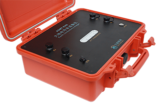
Parts

1. Ex 2. Hx 3. Charging port 4. Connection status 5. Ey 6. Hy 7. Switch 8. Console 9. Sensor
TECHNICAL PARAMETERS
| Console | |
|---|---|
| Display Screen | 7-inch IP highlight touch screen, automatic rotating |
| Resolution | 800*1280 |
| Connection | Multi-functional magnetic suction connector (including charging, USB, signal input), WiFi, Bluetooth |
| Core Features | Optional depth and real-time 2D/3D mapping |
| OS | Android 8.1 |
| CPU | RK3288 quad-core A17 |
| RAM | 2GB |
| Storage | 16GB |
| Battery | 8.4V/6000mAH (can be connected to an external mobile power bank) |
| Power Consumption | 6W |
| Charging | 5V1A, compatible with most mobile phone chargers |
| Dimensions | 238*139*53mm |
| Weight | < 1 kg |
| Working Environment | -20℃~+60℃,95%RH |
| Acquisition Unit | |||||
|---|---|---|---|---|---|
| Versions | EH1 | EH2 | EH4 | EH6 | EH8 |
| Max Depth (m) | ≤1000 | ≤2000 | ≤4000 | ≤6000 | ≤8000 |
| Depths Options (m) | 10-1000 | 10-2000 | 10-4000 | 10-6000 | 10-8000 |
| Channel Mode | MN/TT | ||||
| Connection | Wifi | ||||
| Frequency Range | 0.001~2000 Hz | ||||
| Sensitivity | 1%Fs | ||||
| Resolution | 1uV | ||||
| Frequency-selective Filtering | Pre-set frequency and intelligent frequency selection, analog + digital filtering | ||||
| Input Impedance | ≥ 1M | ||||
| Suppression of 50Hz working interference | ≥ 60dB | ||||
| Sampling Time | 540~10800s | ||||
| Dimensions | 323*275*135mm | ||||
| Battery | 8.4V/7500mAh | ||||
| Power Consumption | 7.5W | ||||
| Weight | 3.5kg | ||||
| Working Environment | -20℃~+60℃,95%RH | ||||
SERVING DOZENS OF COUNTRIES AROUND
THE WORLD, WELL RECEIVED BY USERS

PROFESSIONAL SERVICE TEAM

QUALIFICATION CERTIFICATE
Certificates and Awards: CE, ISO, China National High-tech Enterprise, China National Technical Invention Patent

DEVELOPMENT HISTORY
1973: Developed the domestic short-wire D75 electrical method
1977: Developed an aerial proton magnetometer
1981: Developed domestic resistivity DW83 electrical method
1988: Developed a multi-functional high-power electric method
2001: Developed the NEP series of natural electric field geophysical probes
2005: Completed the "High-Density Electrical Method" project commissioned by the Institute of Geology and Geophysics, Chinese Academy of Sciences
2011: Completed the "Controllable Source Geodetic Electromagnetic Instrument (CSAMT)" project commissioned by the Institute of Geology and Geophysics, Chinese Academy of Sciences
2013: Received the support of the Innovation Fund of the Ministry of Science and Technology, and passed the Shanghai High-tech Achievement Transformation Certification
2017: Developed mobile phone water-finding instrument and geophysical instrument, supporting two-dimensional and three-dimensional automatic mapping of Android system
2018: Independent research and development of 16-channel series products to solve the problem of natural electric field source changes, simple, efficient and precise
2021: Water-finding instrument, geophysical prospecting instrument, aerial geophysical prospecting, earthquake advanced prediction system, etc. will be developed for cloud platform big data automatic analysis function


Two-year
Warranty

Lifetime
After-sales

Professional
Advisors

Free
Upgrade